Snow Predictions for Michigan 2026-2027: A Compleate Prediction

NOAA expects a record El Nino. Across Michigan's 7 strong El Nino winters all ten stations finished below normal, but Muskegon lost half its snow and Marquette lost almost none.
Advertisement
Michigan is not one snow state. It is two, and the gap between them is the widest in the eastern United States. Marquette averages 196.8 inches of snow a season. Detroit Metro averages 45.0. Both numbers come from the same official set of normals, and both are Michigan.
That matters more than usual this year, because NOAA is forecasting a record El Nino, and almost every winter outlook you will read says the same thing about the Great Lakes: warmer, drier, less snow. We went and checked that claim against 77 seasons of daily measurements from ten Michigan weather stations. The claim is broadly right. What nobody has published is how unevenly it lands, and the answer is close to the opposite of what the explanation suggests.
Will it snow in Michigan this winter?
Yes. Michigan has recorded measurable snow in every single season in the modern record at all ten stations we examined, going back to 1949 at some of them. The question worth asking is not whether it snows, but how much, and where in the state you are standing.
Even Michigan's quietest winters on record are not snowless. Detroit Metro's lowest season in 66 years was 17.1 inches in 1968-69. Saginaw's lowest in 77 years was 18.5 inches in 1976-77. Marquette's lowest in 62 years was 71.7 inches, which is still more snow than Detroit gets in a normal winter and more than Atlanta has seen in the last fifty years combined.
What is the Michigan winter forecast for 2026-2027?
Four organisations have published a position that covers Michigan, and they do not fully agree. The table below is what each one actually says, with the date it was issued, rather than a summary of a summary. Every entry here was read directly from the source.
| Source | Issued | What it says about Michigan or the Great Lakes |
|---|---|---|
| NOAA Climate Prediction Center, ENSO Diagnostic Discussion | 13 August 2026 | El Nino Advisory in force. Greater than 90% chance of a very strong event during fall and winter 2026-27. A 69% chance that the October to December peak exceeds every El Nino since 1950. CPC adds that impacts consistent with El Nino become more likely, "but they are not guaranteed". |
| NOAA Climate Prediction Center, Seasonal Outlook discussion | 20 August 2026 | Above normal temperatures favoured across the Great Lakes for September to November. A slight tilt toward below normal precipitation across much of the Great Lakes for the same period. CPC's published plain-language summary covers autumn, not the depth of winter. |
| Farmers' Almanac | 8 August 2026 | Michigan drier than usual with periods of intense cold. Great Lakes temperatures near normal, which the Almanac stresses does not mean a mild winter. Warns that temperatures hovering close to freezing make precipitation type hard to call. |
| The Old Farmer's Almanac | Page updated 14 August 2026 | No free regional Michigan detail on its website, which carries only an explainer on El Nino and the polar vortex. The official 2026-2027 regional predictions are sold inside the printed 2027 edition. Press reports of its Michigan call describe a warmer and drier winter. |
Notice what is missing from all four. Not one of them gives Michigan a snowfall total in inches. That is not an oversight on their part. It is an honest limit of seasonal forecasting, and any page that hands you a number for Detroit or Grand Rapids this far out has invented it.
Is 2026-2027 an El Nino winter?
Yes, and a historically strong one by the current forecast. CPC placed July's Nino-3.4 index at plus 1.4 degrees Celsius on 13 August, and by 20 August the latest weekly value had climbed to plus 1.8. The eastern equatorial Pacific was already running above plus 3.0.
The number driving the headlines is CPC's 69% chance that the October to December peak exceeds every El Nino on record since 1950. One detail gets lost in the retelling: that threshold is stated for RONI, the relative Oceanic Nino Index, not the ONI that historical El Nino lists are built from. The two indices are not interchangeable, which is why the historical comparisons further down this page are a guide and not a like for like match.
Does El Nino mean less snow in Michigan?
On the record, yes, and with unusual consistency. We took the seven strong El Nino winters since 1949, defined as a December to February ONI of plus 1.5 or higher, and compared each station's average across those winters with its own long run average. All ten stations came in below their own normal.
Strong El Nino seasons by CPC's ONI record are 1957-58, 1972-73, 1982-83, 1991-92, 1997-98, 2015-16 and 2023-24. Three of those cleared plus 2.0 and count as very strong: 1982-83, 1997-98 and 2015-16.
| Station | Region | Normal season (1991-2020) | Long run average | Strong El Nino average | Share of normal |
|---|---|---|---|---|---|
| Marquette | Upper Peninsula | 196.8" | 183.0" | 161.6" | 88% |
| Sault Ste Marie | Eastern UP | 120.1" | 121.3" | 91.2" | 75% |
| Muskegon | West lakeshore | 87.2" | 95.5" | 67.4" | 71% |
| Alpena | Northeast Lower | 77.6" | 79.9" | 68.0" | 85% |
| Grand Rapids | West Michigan | 77.6" | 74.2" | 59.6" | 80% |
| Houghton Lake | Central Lower | 65.9" | 70.1" | 56.0" | 80% |
| Flint | East Central | 52.1" | 49.1" | 43.5" | 89% |
| Lansing | Central | 50.2" | 50.8" | 49.5" | 98% |
| Saginaw | Saginaw Valley | 49.0" | 45.7" | 40.7" | 89% |
| Detroit Metro | Southeast | 45.0" | 42.7" | 31.8" | 74% |
Ten stations, ten deficits, no exceptions. For comparison we ran the same test on strong La Nina winters, with an ONI of minus 1.0 or lower. Nine of the ten stations came in at or above their long run average there, Houghton Lake at 125% and Alpena at 113%. The El Nino signal in Michigan is real and it points one way.
Which parts of Michigan lose the most snow in an El Nino?
This is where the standard explanation breaks. Nearly every outlook attributes the Great Lakes deficit to weakened lake effect snow, since warmer air over the lakes produces less of it. If that were the whole story, Michigan's biggest lake effect machines would take the biggest hit. They take the smallest.
Restricting the test to the three very strong events only, the pattern sharpens into something close to a north south split.
| Station | Long run average | Very strong El Nino average | Share of normal |
|---|---|---|---|
| Alpena | 79.9" | 81.3" | 102% |
| Marquette | 183.0" | 180.9" | 99% |
| Flint | 49.1" | 43.6" | 89% |
| Saginaw | 45.7" | 37.8" | 83% |
| Lansing | 50.8" | 41.8" | 82% |
| Houghton Lake | 70.1" | 55.0" | 78% |
| Sault Ste Marie | 121.3" | 89.6" | 74% |
| Grand Rapids | 74.2" | 52.3" | 70% |
| Detroit Metro | 42.7" | 26.2" | 61% |
| Muskegon | 95.5" | 48.6" | 51% |
Marquette, the snowiest reporting station in the state and the heart of Michigan's lake effect belt, loses essentially nothing in the three strongest El Ninos on record. Alpena finishes slightly above its own average. Muskegon, which sits directly downwind of Lake Michigan and is also a lake effect town, loses almost half its season.
So "El Nino weakens lake effect snow" does not survive contact with the record. Two lake effect stations sit at opposite ends of the outcome. What separates them is latitude and the source of the snow. Marquette is far enough north and cold enough that its lake effect season runs whatever the Pacific is doing, and its normals show measurable snow from September through May. Muskegon, Grand Rapids and Detroit depend far more on organised storm systems tracking through the Great Lakes, and a strong El Nino is exactly what pushes that storm track south into the Ohio Valley and beyond.
What happened in Michigan during the last big El Nino winters?
Seven strong El Ninos have occurred since 1949, and they produced markedly different Michigan winters. Presenting only the ones that support a headline would be dishonest, so all seven appear below, with each station's season shown as a percentage of its own long run average rather than as raw inches.
| Season | ONI | Marquette | Sault Ste Marie | Alpena | Muskegon | Grand Rapids | Lansing | Flint | Detroit |
|---|---|---|---|---|---|---|---|---|---|
| 1957-58 | 1.7 | n/a | 62% | 36% | 93% | n/a | n/a | 49% | n/a |
| 1972-73 | 1.6 | 52% | 76% | 105% | 80% | 88% | 148% | 128% | 105% |
| 1982-83 | 2.1 | 109% | 72% | 92% | 37% | 48% | 66% | 68% | 47% |
| 1991-92 | 1.5 | 112% | 93% | 107% | 89% | 118% | 115% | 111% | 102% |
| 1997-98 | 2.2 | 100% | n/a | n/a | n/a | 81% | n/a | 58% | 55% |
| 2015-16 | 2.5 | 88% | 76% | 111% | 65% | 82% | 98% | 141% | 83% |
| 2023-24 | 1.8 | 69% | 72% | 60% | 58% | 64% | 60% | 65% | 55% |
Read across the rows and the averages stop looking like a forecast. 1991-92 was a strong El Nino in which most of Michigan finished at or above normal. 1972-73 gave Lansing 148% of its average. The averages in the earlier tables are pulled down by a small number of severe seasons, not by a reliable annual tax on Michigan's snowfall.
What was the strangest El Nino winter in Michigan?
1982-83, and it is the single most useful winter on this page. The ONI hit plus 2.1, the second strongest reading in the record at the time. What it did to Michigan was not a statewide reduction. It split the state cleanly in half, and it did so at record breaking scale.
In that one season, four Michigan stations recorded the lowest snowfall total in their entire history: Pellston, Traverse City, Muskegon and Grand Rapids. Detroit Metro finished third lowest in 66 years. Saginaw finished fourth lowest in 77. Jackson finished second lowest in 50.
Advertisement
In the same winter, at the same time, Marquette recorded 199.3 inches. That is above its long run average of 183.0 and sits in the 63rd percentile of its own record, an ordinary to good Upper Peninsula winter. One El Nino, one state, and the southern half setting all time lows while the north shovelled a normal season.
Did the strongest El Nino on record bring Michigan a snowless winter?
No, and this is the fact that cuts hardest against the story we have been building. The strongest El Nino in the entire ONI record is 2015-16, at plus 2.5. Michigan came through it close to normal, and several stations finished above their own averages that season.
Flint recorded 69.0 inches in 2015-16, its 66th lowest season out of 77, which places it comfortably in the upper third of its record. Saginaw landed in the 71st percentile, Alpena in the 69th, Lansing in the 55th. Detroit and Marquette both came in below normal but nowhere near record territory.
The most recent strong El Nino behaved completely differently. In 2023-24 every one of the ten stations finished inside the bottom 18% of its own record, six of them inside the bottom 10%. Houghton Lake had its second lowest season in 57 years. Grand Rapids had its third lowest in 62.
Strongest event, near normal Michigan winter. A weaker event two years ago, near record lows almost everywhere. Anyone telling you a record El Nino guarantees a snowless Michigan winter is reading a pattern the data does not contain, and CPC said as much itself when it wrote that El Nino impacts "are not guaranteed".
How much snow does Michigan get a year?
It depends on which Michigan, and the spread is enormous. The official NCEI normals covering 1991 to 2020 put Marquette at 196.8 inches and Detroit Metro at 45.0. That is a factor of more than four across a single state, and it is the number to anchor any Michigan snow question to.
| Place | Normal season | Snowiest season on record | Least snowy on record | Seasons measured |
|---|---|---|---|---|
| Marquette | 196.8" | 319.8" (2001-02) | 71.7" (1967-68) | 62 |
| Sault Ste Marie | 120.1" | 222.0" (1995-96) | 65.5" (1960-61) | 75 |
| Muskegon | 87.2" | 173.9" (1981-82) | 35.5" (1982-83) | 74 |
| Alpena | 77.6" | 166.3" (1970-71) | 28.7" (1957-58) | 72 |
| Grand Rapids | 77.6" | 116.0" (2013-14) | 35.9" (1982-83) | 62 |
| Houghton Lake | 65.9" | 124.1" (1970-71) | 30.7" (2009-10) | 57 |
| Flint | 52.1" | 85.3" (2017-18) | 23.4" (1952-53) | 77 |
| Lansing | 50.2" | 88.8" (1951-52) | 20.7" (1952-53) | 64 |
| Saginaw | 49.0" | 87.2" (1966-67) | 18.5" (1976-77) | 77 |
| Detroit Metro | 45.0" | 94.9" (2013-14) | 17.1" (1968-69) | 66 |
One pattern in that table is worth pausing on. Grand Rapids and Detroit both set their all time records in the same season, 2013-14, and the ONI that winter was minus 0.24, which is neutral. Muskegon's record of 173.9 inches came in 1981-82, also neutral. Michigan's biggest winters have not come from El Nino or La Nina. They came when the Pacific was doing nothing in particular.
What did the last 5 years of Michigan snow look like?
The last five completed winters cover one strong El Nino and four seasons of weak La Nina or neutral conditions, which makes 2023-24 stand out sharply from its neighbours. All figures are totals rebuilt from daily measurements, and every season shown here is complete.
| Place | Normal | 2021-22 | 2022-23 | 2023-24 | 2024-25 | 2025-26 |
|---|---|---|---|---|---|---|
| Marquette | 196.8" | 204.7" | 265.1" | 126.5" | 181.4" | 276.6" |
| Sault Ste Marie | 120.1" | 135.4" | 161.7" | 87.0" | 203.3" | 189.2" |
| Muskegon | 87.2" | 58.0" | 60.1" | 55.5" | 75.7" | 108.5" |
| Alpena | 77.6" | 69.1" | 70.9" | 48.2" | 72.5" | 90.4" |
| Grand Rapids | 77.6" | 71.0" | 110.7" | 47.5" | 63.8" | 75.4" |
| Houghton Lake | 65.9" | 50.8" | 62.5" | 32.4" | 80.8" | 72.9" |
| Flint | 52.1" | 60.5" | 46.5" | 32.0" | 39.7" | 46.3" |
| Lansing | 50.2" | 58.1" | 58.1" | 30.5" | 37.7" | 41.6" |
| Saginaw | 49.0" | 36.3" | 46.7" | 32.2" | 32.3" | 35.6" |
| Detroit Metro | 45.0" | 47.1" | 37.1" | 28.7" | 39.5" | 39.5" |
| DJF ONI | -0.76 | -0.55 | +1.84 | -0.46 | -0.39 |
Two things jump out. 2023-24, the El Nino winter, is the lowest column for eight of the ten stations. And the winter that just ended, 2025-26, was the second snowiest season Marquette has recorded in 62 years at 276.6 inches, beaten only by 2001-02.
Where does it snow the most in Michigan?
The Upper Peninsula, and it is not close. Marquette's normal season of 196.8 inches is more than four times Detroit's, and the surrounding Keweenaw highlands run higher still. Sault Ste Marie in the eastern UP averages 120.1 inches, itself more than double what most of southern Michigan sees.
The eastern Upper Peninsula has just been through a remarkable run. Sault Ste Marie recorded 203.3 inches in 2024-25, its second snowiest season in 75 years of records, then followed it with 189.2 inches in 2025-26, its third snowiest. Back to back top three winters at the same station is rare in any record.
How much snow does Detroit get?
Detroit Metro averages 45.0 inches a season under the 1991 to 2020 normals, spread mostly across December, January and February. Its snowiest winter on record is 94.9 inches in 2013-14 and its quietest is 17.1 inches in 1968-69, so the realistic range is wide.
Detroit is the Michigan station most sensitive to a strong El Nino in this analysis, finishing at 74% of its long run average across the seven events and 61% across the three very strong ones. In 1982-83 it managed 20.0 inches, its third lowest season in 66 years, and in 2023-24 it managed 23.5.
How much snow does Grand Rapids get?
Grand Rapids averages 77.6 inches a season, which is close to Alpena's total and roughly 70% more than Detroit's. It holds one of the most interesting records in the state, having set both its all time high of 116.0 inches and, thirty one years earlier, its all time low.
Its low was 35.9 inches in 1982-83, the strong El Nino winter that also produced record lows at Muskegon, Pellston and Traverse City. Its high of 116.0 inches came in 2013-14, a neutral winter. Grand Rapids swings harder than any other station in southern Michigan.
How much snow do Marquette and the Upper Peninsula get?
Marquette's normal season is 196.8 inches, the highest of any reporting station in this analysis. Its record is 319.8 inches in 2001-02, and it has cleared 240 inches six times since 1961. Its lowest season on record, 71.7 inches, still exceeds a normal Detroit winter by more than half.
The Upper Peninsula season is also much longer than the rest of the state's. Marquette's normals show measurable snowfall in every month from September through May, with 17.6 inches falling in April alone. Detroit's normals show nothing before November and 1.5 inches in April.
How much snow does Traverse City get?
Traverse City averaged 89.9 inches across the 46 seasons in its usable record, which puts it between Muskegon and Alpena. There is an honest limitation here worth stating plainly: Traverse City's airport stopped reporting daily snowfall in the 1990s, so it cannot appear in the recent tables on this page.
The same applies to Pellston, at 108.9 inches across 50 seasons, and Jackson at 38.4 across 50. All three were dropped from the modern comparisons rather than filled in with estimates. For current conditions in that part of the state, the National Weather Service office in Gaylord covers the northern Lower Peninsula.
What is lake effect snow and why does Michigan get so much?
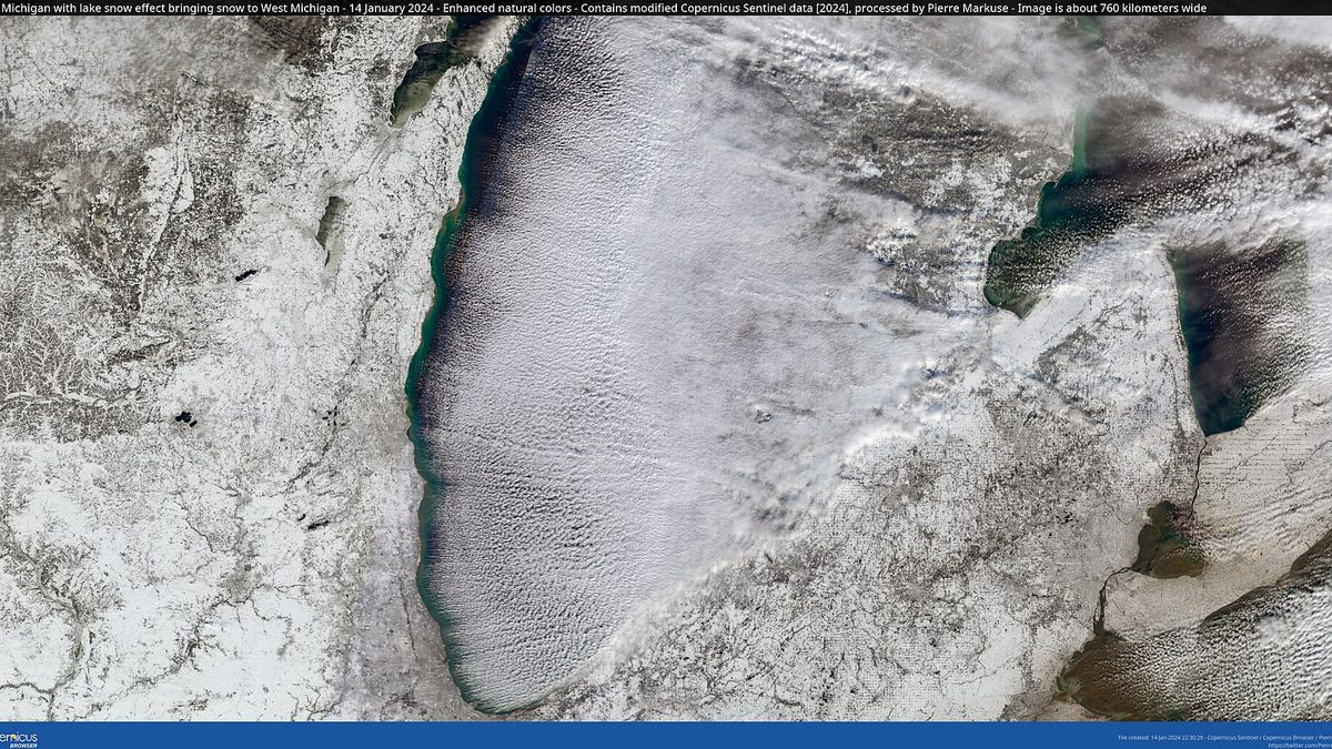
Lake effect snow forms when cold air crosses the relatively warm, open water of the Great Lakes. The air picks up heat and moisture, becomes unstable, then dumps that moisture as snow when it reaches land. Michigan is surrounded by four of the five Great Lakes, so it collects this from several directions.
The two belts that matter most are the western Lower Peninsula shoreline, where Muskegon, Grand Rapids and Holland sit downwind of Lake Michigan, and the northern and western Upper Peninsula, where Marquette sits downwind of Lake Superior. Lake effect needs a large temperature contrast between water and air, which is why it fades once the lakes ice over and why an unusually warm autumn can delay the season's start.
When does it snow in Michigan?
January is the peak month almost everywhere in the state, and the season runs longer the further north you go. Detroit's normals show snow from November to April, six months. Marquette's run from September to May, nine months, with a heavier April than Detroit records in its entire winter.
| Place | Nov | Dec | Jan | Feb | Mar | Apr |
|---|---|---|---|---|---|---|
| Marquette | 24.2" | 39.9" | 42.1" | 36.8" | 29.4" | 17.6" |
| Sault Ste Marie | 16.0" | 30.4" | 30.3" | 20.7" | 13.0" | 7.6" |
| Muskegon | 6.5" | 22.3" | 29.1" | 20.0" | 7.5" | 1.8" |
| Alpena | 6.6" | 16.9" | 19.3" | 17.0" | 10.6" | 6.6" |
| Grand Rapids | 7.1" | 20.8" | 22.6" | 17.2" | 7.6" | 2.0" |
| Houghton Lake | 7.5" | 15.1" | 16.4" | 13.6" | 8.3" | 4.4" |
| Flint | 3.3" | 11.4" | 15.1" | 13.0" | 6.6" | 2.4" |
| Lansing | 3.9" | 11.3" | 14.3" | 12.9" | 5.9" | 1.7" |
| Saginaw | 3.3" | 11.8" | 13.9" | 11.4" | 6.0" | 2.4" |
| Detroit Metro | 1.9" | 8.9" | 14.0" | 12.5" | 6.2" | 1.5" |
Muskegon is the outlier in shape rather than size. Its snow is heavily loaded into December and January, when Lake Michigan is still open and lake effect is at full strength, then collapses to 7.5 inches in March. Marquette, by contrast, is still averaging 29.4 inches in March.
Advertisement
What was the biggest snowstorm in Michigan history?
Measured by a single calendar day at a long term station, the record belongs to Sault Ste Marie, which recorded 26.6 inches on 10 December 1995. Marquette comes second with 26.2 inches on 14 March 1997, which shows how late the Upper Peninsula season can still deliver.
| Place | Largest single day | Date |
|---|---|---|
| Sault Ste Marie | 26.6" | 10 December 1995 |
| Marquette | 26.2" | 14 March 1997 |
| Muskegon | 22.0" | 10 January 1982 |
| Saginaw | 21.3" | 17 March 1973 |
| Detroit Metro | 18.4" | 1 December 1974 |
| Alpena | 17.3" | 4 March 1985 |
| Grand Rapids | 16.1" | 26 January 1978 |
| Houghton Lake | 15.4" | 26 January 1978 |
| Lansing | 15.4" | 26 January 1967 |
| Flint | 14.5" | 26 January 1967 |
Two dates appear twice in that table. 26 January 1978 is the Great Blizzard of 1978, which hit Grand Rapids and Houghton Lake on the same day and remains the storm older Michiganders measure others against. 26 January 1967 set the single day record at both Lansing and Flint.
What to do with this before winter
The useful conclusion from 77 seasons of measurements is not a single number for this winter. It is a clear sense of the realistic range where you actually live and travel, which is what lets you plan a season sensibly without either panicking early or being caught out in January.
- Use your own station's normal, not the state's. "Michigan snow" is a meaningless planning figure when it spans 45 to 197 inches. Find the closest place in the tables above and work from that.
- Plan for the range, not the average. Detroit's record spans 17.1 to 94.9 inches. Grand Rapids spans 35.9 to 116.0. A season can land anywhere in that band regardless of what the Pacific is doing.
- If you are travelling north, budget more season, not just more snow. Marquette averages 17.6 inches in April. A spring trip to the Upper Peninsula is a winter trip.
- Watch the October to December CPC updates rather than August ones. The next ENSO discussion is due 10 September 2026, and the outlooks that actually cover deep winter arrive in mid autumn.
- Check the road authority, not the forecast, on the day. The Michigan Department of Transportation runs live winter road conditions, which matters far more for a specific trip than any seasonal outlook.
What this record cannot tell you
Several real limits apply to everything above, and they are worth stating plainly rather than burying at the bottom. This page occupies a question that seasonal forecasting cannot actually answer for a specific city, and pretending otherwise would make it less useful to you, not more.
The sample is small. Seven strong El Nino winters, and only three very strong ones, is not many, and individual station coverage within them is thinner still. Marquette contributes six of seven and Sault Ste Marie two of three very strong seasons. A single unusual winter moves these averages noticeably.
The indices are not matched. CPC's 69% headline figure is stated for RONI, while the historical seasons here are classified by ONI. Comparing a RONI forecast to an ONI composite is directionally useful and technically imprecise.
Measurement practice has changed. Snowfall observation methods and station equipment have shifted across a 77 year record, and airport stations in particular have moved and automated. Older totals and modern totals are not perfectly comparable, which is one reason we report normals from NCEI alongside our own long run averages rather than instead of them.
And no forecast here is ours. We have not predicted Michigan's 2026-2027 snowfall and will not, because no credible method exists to produce a seasonal snowfall total for a specific city months ahead. What we have done is show you what has actually happened in comparable winters.
Common questions
Will Michigan get less snow because of El Nino in 2026-2027?
The record leans that way without promising it. All ten stations averaged below normal across seven strong El Nino winters, and the most recent one in 2023-24 was near record low statewide. The strongest El Nino ever recorded, in 2015-16, produced a close to normal Michigan winter.
Is the Upper Peninsula affected by El Nino the same way as Detroit?
No, and the difference is large. Across the three very strong El Ninos Marquette averaged 99% of its normal snowfall while Detroit Metro averaged 61%. Alpena in the northeast Lower Peninsula came out slightly above normal at 102%. The southern half of the state carries most of the deficit.
What is the snowiest place in Michigan?
Among long term reporting stations, Marquette, at a normal season of 196.8 inches and a record of 319.8 inches set in 2001-02. The Keweenaw Peninsula further west is snowier still, though its long running Houghton County station stopped reporting in 2000 and cannot be compared on the same basis.
How many inches of snow will Detroit get this winter?
Nobody can tell you, and any page giving a figure is guessing. Detroit Metro's normal is 45.0 inches, its record range across 66 seasons runs from 17.1 to 94.9 inches, and in the seven strong El Nino winters it averaged 31.8 inches. That is the honest answer available in August.
Does it snow in Michigan in April?
Regularly in the north, occasionally in the south. Marquette's normals include 17.6 inches in April and 1.4 inches in May. Detroit's April normal is 1.5 inches and its normals show nothing in May. Alpena and Houghton Lake sit between the two at 6.6 and 4.4 inches respectively.
When was Michigan's snowiest winter?
It depends on the station, which is the recurring lesson of this page. Marquette's was 2001-02 at 319.8 inches. Sault Ste Marie's was 1995-96 at 222.0. Grand Rapids and Detroit Metro both set their records in 2013-14, at 116.0 and 94.9 inches, during a neutral Pacific winter.
Sources
- NOAA Climate Prediction Center, ENSO Diagnostic Discussion, issued 13 August 2026. El Nino Advisory, greater than 90% chance of a very strong event, July Nino-3.4 at plus 1.4 degrees Celsius, and the 69% figure for October to December. Next update due 10 September 2026.
- NOAA Climate Prediction Center, Prognostic Discussion for Long-Lead Seasonal Outlooks, issued 8:30 AM EDT, 20 August 2026. Source of the Great Lakes temperature and precipitation wording and the plus 1.8 weekly Nino-3.4 value.
- NOAA Climate Prediction Center, Oceanic Nino Index historical file. Every ONI value on this page, and the classification of the seven strong and three very strong El Nino winters, comes from this file.
- Applied Climate Information System (ACIS), Regional Climate Centers. All station snowfall totals were rebuilt from daily observations retrieved through the ACIS StnData service for 1949 to 2026.
- NOAA NCEI US Climate Normals, 1991-2020. Every "normal season" and monthly normal figure on this page.
- The Old Farmer's Almanac, Winter Weather Predictions 2026-2027, page last modified 14 August 2026. Checked 27 August 2026: carries only the climate-signals explainer, with the regional forecasts sold in the printed 2027 edition.
- Farmers' Almanac, the separate publication that issued its 2026-2027 winter forecast on 8 August 2026.
- Detroit Free Press, Farmers' Almanac predicts Michigan's winter weather. Source of the Michigan-specific Farmers' Almanac wording and of the reported Old Farmer's Almanac position for Michigan.
- Fox Weather, Farmers' Almanac releases 2026-2027 winter forecast. National context for the same forecast.
- National Weather Service, Marquette, Gaylord, Grand Rapids and Detroit and Pontiac forecast offices, the authoritative source for current conditions and warnings in each part of the state.
- NOAA Great Lakes Environmental Research Laboratory, for lake temperature and ice cover, which drive the lake effect season.
- Michigan Department of Transportation for live winter road conditions, and NWS winter safety guidance for preparation.
Related reading on this site: our national winter snow predictions guide covers the same El Nino against every US region. The Pittsburgh winter forecast and the Pennsylvania snow guide apply the same method to the other side of the Great Lakes. For the mirror image of Michigan's deficit, our Texas snow guide shows where that displaced southern storm track actually ends up. And the two sides of the winter forecast explains why the almanacs and NOAA so often disagree.
All snowfall figures on this page were rebuilt from daily station observations and last verified on 27 August 2026. Where a season could not be reconstructed without gaps, it was excluded rather than estimated, and the number of usable seasons is stated for every station.
Topics
Advertisement