Minnesota Snow Predictions 2026-2027: Will It Be a Snowy Winter?

Will Minnesota have a snowy winter in 2026-2027? NOAA, Farmers' Almanac and Old Farmer's Almanac compared, plus real snowfall history for Minneapolis and Duluth.
Advertisement
Minnesota's winter forecast for 2026-2027 leans milder and drier than normal, driven by one of the strongest El Ninos on record. NOAA, the Farmers' Almanac and the Old Farmer's Almanac don't fully agree on the details, and the Twin Cities' own history shows El Nino has failed to deliver a mild winter before.
Key facts:
- 2026-2027 outlook: warmer than normal statewide, with historically about 24% less snow in the Twin Cities during El Nino winters
- Twin Cities normal: 51.2 inches a season (1991-2020 normal)
- Duluth normal: 90.2 inches a season, almost double the Twin Cities, because of Lake Superior
- State snowfall record: 170.5 inches, Pigeon River Bridge near Grand Portage, winter 1949-50
- El Nino does not guarantee a mild winter: the 1991 Halloween Blizzard hit during an El Nino winter and dropped 28.4 inches on the Twin Cities
- First snow, on average: late October in Duluth, early November in the Twin Cities
What kind of winter is Minnesota getting in 2026-2027?
Milder and drier than normal, but not snow-free. NOAA's Climate Prediction Center, the Farmers' Almanac and the Old Farmer's Almanac all point toward a strong El Nino pattern, and all three still describe real cold snaps and snowy stretches inside that milder season. None of them publishes a specific inches total for this winter, and neither do we.
What does NOAA's El Nino forecast say about Minnesota snow?
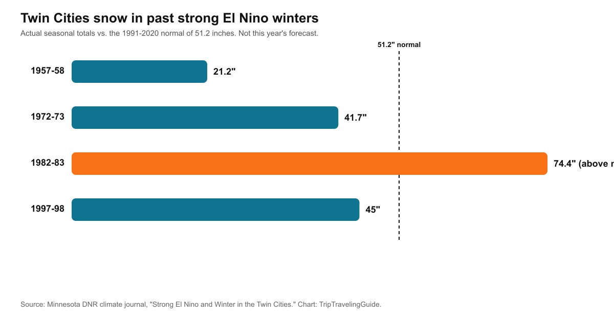
NOAA's Climate Prediction Center, in its ENSO diagnostic discussion, put the odds of a very strong El Nino this fall and winter above 90 percent, with a real chance it becomes the strongest El Nino episode on record dating back to 1950. For Minnesota, the Minnesota DNR's own climate record shows the 27 El Nino winters since 1950 averaged 2.4 degrees Fahrenheit warmer than non-El Nino winters, and produced about 24 percent less snow in the Twin Cities, roughly 13.7 inches below the seasonal norm.
That is a historical average across nearly three dozen winters, not a promise for this specific season. Individual El Nino winters in Minnesota's own record have landed anywhere from well below that average to well above it, which is the next section.
What does the Farmers' Almanac predict for Minnesota this winter?
Cold, snowy at times, and breezy, grouping Minnesota into its North Central region. The Farmers' Almanac's 2026-2027 outlook calls for temperatures above normal overall, but with sudden cold snaps and what it describes as fast-moving clippers and squalls, brief bursts of heavy snow driven by arctic wind rather than one long snowy stretch.
Its snowiest windows for the region are called out as early and late January, late February, and early March, with the coldest stretch expected mid- to late January. Precipitation is forecast above normal in the eastern half of the region and below normal in the west, and snowfall itself is called near to below normal overall, a milder headline with real snow squalls built into it.
What does the Old Farmer's Almanac predict for Minnesota this winter?
Near-normal temperatures but a volatile season, with fast-moving clippers, sudden cold snaps and brief thaws in between. The Old Farmer's Almanac's Upper Midwest outlook leans toward a drier winter overall, broadly in the same direction as the Farmers' Almanac despite the two publications using separate methods and separate regional zones.
Worth stating plainly: the Old Farmer's Almanac's forecasting method is not built on the same climate science NOAA uses, and its seasonal calls do not always line up with the Climate Prediction Center's. We are reporting what it says, not treating it as equivalent to a NOAA outlook.
NOAA vs Farmers' Almanac vs Old Farmer's Almanac: where they agree and disagree
All three agree Minnesota's winter will not be uniformly mild, and all three call out real cold and snow within an otherwise milder season. Where they diverge is emphasis: NOAA's statewide El Nino average points toward meaningfully less snow, while both almanacs frame the season around sudden, sharp snowy bursts rather than a steady below-normal total.
Advertisement
| Source | Temperature call | Snowfall call | Notable timing |
|---|---|---|---|
| NOAA Climate Prediction Center | Warmer than normal statewide | Historically ~24% below normal in El Nino winters | Pattern holds through the season |
| Farmers' Almanac | Above normal, sudden cold snaps | Near to below normal, brief heavy squalls | Early/late Jan, late Feb, early Mar |
| Old Farmer's Almanac | Near normal, volatile | Trending drier overall | Coldest mid-to-late January |
Why does El Nino usually mean less snow for Minnesota?
Because a strong El Nino tends to push the polar jet stream north, steering the coldest air and the heaviest storm tracks away from the Upper Midwest and toward western Canada and Alaska instead. With fewer Arctic outbreaks reaching Minnesota, both the frequency and intensity of snow-producing storms tend to drop, which is the mechanism behind NOAA's warmer, less-snowy statewide average.
Can a big snowstorm still hit Minnesota in an El Nino year?
Yes. The Minnesota DNR's own guidance is blunt about it: El Nino does not mean winter is canceled, and a lower seasonal average can still contain a single storm severe enough to be remembered for decades.
The clearest example is the Halloween Blizzard of 1991, which struck during an El Nino winter and dropped 28.4 inches of snow on the Twin Cities, with Duluth measuring 36.9 inches, a state record at the time. About 20 deaths were attributed to the storm and roughly 900 schools and businesses closed. A milder seasonal lean did nothing to stop it.
Minnesota's snowiest winters in history: has this happened before?
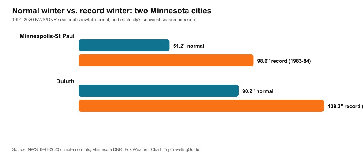
Yes, several times. The Twin Cities' snowiest season on record is 1983-84 at 98.6 inches, followed by 1981-82 at 95 inches. Duluth's record season is far more recent: 2022-23, with 138.3 inches, breaking the previous record of 135.4 inches set in 1995-96. The all-time state record for a single season is 170.5 inches, recorded at the Pigeon River Bridge near Grand Portage in the 1949-50 winter.
One of the four strong El Nino winters in Minnesota's own record, 1982-83, actually landed 20 inches above normal at 74.4 inches, the single exception to the otherwise below-normal pattern. That winter also delivered a mid-December blizzard severe enough to collapse the roof of the Metrodome. History's lesson here is not that El Nino guarantees a quiet winter, only that it tilts the odds toward one.
How much snow does Minnesota get in a normal year?
51.2 inches a season in the Twin Cities, and 90.2 inches in Duluth, per the National Weather Service's 1991-2020 climate normals. December is the snowiest month in both cities, and in Duluth it averages 19.5 inches on its own, close to what the Twin Cities gets across three months combined.
| City | 1991-2020 seasonal normal | Snowiest season on record | All-time single storm nearby |
|---|---|---|---|
| Minneapolis-St Paul | 51.2 in | 98.6 in (1983-84) | 28.4 in, Halloween Blizzard, 1991 |
| Duluth | 90.2 in | 138.3 in (2022-23) | 36.9 in, Halloween Blizzard, 1991 |
Why does Duluth get almost double the snow of Minneapolis?
Lake Superior's lake-effect snow. Duluth sits directly on the lake's western tip, and cold air moving across the open, relatively warm water picks up moisture and dumps it as lake-effect snow on the city and the North Shore just downwind. Minneapolis-St Paul, roughly 150 miles inland from Lake Superior, gets almost none of that effect and relies on ordinary storm systems for its snow instead, which is the main reason its seasonal total runs so far below Duluth's.
Advertisement
When does it usually start snowing in Minnesota?
Late October in Duluth, early November in the Twin Cities, per 30-year NOAA/NWS averages. Our first snow date guide covers both cities alongside the rest of the country in more detail, including how far the actual date can swing from that average in any given year.
What does this mean for winter travel in Minnesota?
Plan around the state's real climate record, not a single seasonal headline. Our USA winter forecast hub lays out how NOAA and both almanacs compare across the country, and our white Christmas odds guide already puts Minnesota among the states with the best historical odds of snow on the ground December 25, a figure a milder seasonal lean can shift but is unlikely to erase.
What are the limits of this forecast data?
A seasonal outlook describes a tendency across an entire winter, not a forecast for any single storm, flight or weekend. NOAA's own statewide El Nino average is built from 27 winters with real spread between them, and Minnesota's own record includes an El Nino winter, 1982-83, that landed well above normal. The Old Farmer's Almanac's method in particular is not built the same way NOAA's climate science is, and its seasonal calls do not always track the Climate Prediction Center's.
We have not merged the two almanacs' claims into one number, and nothing in this guide predicts a specific snowfall total for 2026-2027. For a seasonal outlook to matter for a specific trip, check the National Weather Service's short-range forecast for Minnesota closer to your travel date rather than relying on any seasonal outlook alone.
Quick answers about Minnesota's winter 2026-2027
Will Minnesota have a snowy winter in 2026-2027?
Most likely near to below normal statewide, per NOAA's El Nino-driven outlook, though both almanacs still call for real snowy bursts within that milder season.
Is Minnesota going to have a snowy winter this year, or a mild one?
Leaning mild in the headline temperature and snowfall trend, but not mild in every individual storm. Minnesota's own record shows El Nino winters can still deliver major snow events.
What kind of winter will Minnesota have this year?
A strong El Nino winter: warmer than normal on average, with sudden cold snaps and brief heavy snow squalls rather than one long snowy stretch, per NOAA and both almanacs.
How much snow does Duluth get on average?
90.2 inches a season, the NWS 1991-2020 normal, roughly double the Twin Cities' 51.2-inch normal.
What is Minnesota's snowfall record?
170.5 inches in a single season, recorded at the Pigeon River Bridge near Grand Portage in 1949-50, the official statewide record.
Did the Halloween Blizzard of 1991 happen during an El Nino winter?
Yes. It dropped 28.4 inches on the Twin Cities and 36.9 inches on Duluth despite the seasonal pattern, which is why the Minnesota DNR cautions that El Nino lowers the odds of a big winter without eliminating them.
Sources
- Minnesota DNR climate journal, "Strong El Nino and Winter in the Twin Cities"
- Minnesota DNR, "Top Ten Season Snowfall Records for the Twin Cities"
- NWS Duluth 1991-2020 climate normals
- Fox Weather, Duluth snowiest-winter-on-record coverage
- NOAA Climate Prediction Center ENSO diagnostic discussion, August 2026
- Farmers' Almanac 2026-2027 winter forecast
- Old Farmer's Almanac 2026-2027 winter forecast
- MinnPost and Minnesota Historical Society, Halloween Blizzard of 1991
Topics
Advertisement