Wisconsin Snow Predictions 2026-2027: NOAA vs the Almanacs

Will Wisconsin have a snowy winter in 2026-2027? NOAA, Farmers' Almanac and Old Farmer's Almanac disagree on snow. Real Milwaukee, Madison and Hurley snowfall history.
Advertisement
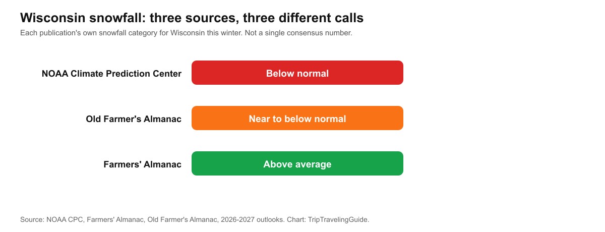
Wisconsin's winter forecast for 2026-2027 splits three ways on snow, even though all three forecasters agree on a strong El Nino. NOAA's Climate Prediction Center calls for below-normal snow statewide, the Old Farmer's Almanac leans the same way, and the Farmers' Almanac puts Wisconsin in its "above average" snowfall category.
Key facts:
- 2026-2027 outlook: warmer than normal statewide, but NOAA, the Farmers' Almanac and the Old Farmer's Almanac disagree on whether snowfall lands above or below normal
- Madison normal: 51.8 inches a season (1991-2020 normal)
- Milwaukee normal: 48.7 inches a season
- Green Bay normal: 55.6 inches a season
- Snowiest town: Hurley, in the Lake Superior snowbelt, averages 174.4 inches a season and holds the state record at 295.4 inches (1996-97)
- El Nino does not guarantee a mild winter: the 1991 Halloween Blizzard hit western Wisconsin during an El Nino winter, dropping 32 inches on Brule
Will it snow in Wisconsin this winter?
Yes. Wisconsin gets measurable snow every winter without exception, the only real question each year is how much and when. The state's three biggest cities each average roughly 48 to 56 inches a season, and the far north, in the Lake Superior snowbelt, averages well over 100 inches most years. What changes winter to winter is the total and the timing, not whether snow shows up at all.
What kind of winter is Wisconsin getting in 2026-2027?
Warmer than normal almost everywhere agrees, but the snow call splits three ways. NOAA's Climate Prediction Center and the Old Farmer's Almanac both lean toward below-normal snowfall for Wisconsin this winter, while the Farmers' Almanac calls the state "above average" for snow despite also expecting near-normal temperatures. None of the three gives a specific inches total, and neither do we.
What does NOAA's El Nino forecast say about Wisconsin snow?
Well above normal temperatures, with the strongest warming concentrated in the north. NOAA's Climate Prediction Center expects a greater than 90 percent chance of a very strong El Nino this fall and winter, and for Wisconsin specifically, the strongest warm anomalies are projected across the Upper Midwest, including northern Wisconsin, where some model runs show departures of 4 to 6 degrees Fahrenheit above normal.
On snow, NOAA's outlook calls for below-average totals across the northern Great Lakes, Minnesota, Wisconsin and Michigan's Upper Peninsula included, on the reasoning that warmer air converts more winter storms into rain or mixed precipitation instead of pure snow.
What does the Farmers' Almanac predict for Wisconsin this winter?
Near-normal temperatures but real volatility, and an explicit above-average snowfall call that runs against NOAA's. The Farmers' Almanac's 2026-2027 outlook groups Wisconsin with the wider Great Lakes and Upper Midwest, describing fast-moving clippers, sudden cold snaps and brief snowy periods broken up by milder spells, a pattern it sums up as "chill, snow, repeat."
Its timing calls out Wisconsin's most intense winter weather for late January into early February, when the almanac expects both the heaviest snow and the coldest air of the season to land.
What does the Old Farmer's Almanac predict for Wisconsin this winter?
Warmer than normal, with snowfall near to below normal, broadly matching NOAA's lean rather than the Farmers' Almanac's. The Old Farmer's Almanac's Upper Midwest outlook calls for above-normal precipitation in the eastern part of the region and below-normal in the west, with the coldest stretch landing mid- to late January.
Worth repeating here too: the Old Farmer's Almanac's method is not built on NOAA's climate science, and its seasonal calls do not always track the Climate Prediction Center's, even when the two end up pointing the same direction this time.
NOAA vs Farmers' Almanac vs Old Farmer's Almanac: where they agree and disagree
All three agree Wisconsin's winter runs warmer than a typical year, driven by the same strong El Nino. They do not agree on snow. NOAA and the Old Farmer's Almanac both lean below normal, while the Farmers' Almanac puts Wisconsin in its above-average snowfall bracket, a direct contradiction we are not going to paper over.
Advertisement
| Source | Temperature call | Snowfall call | Notable timing |
|---|---|---|---|
| NOAA Climate Prediction Center | Well above normal, strongest in the north | Below normal statewide | Pattern holds through the season |
| Farmers' Almanac | Near normal, volatile | Above average | Late Jan to early Feb |
| Old Farmer's Almanac | Warmer than normal | Near to below normal | Coldest mid-to-late January |
Why does El Nino usually mean less snow for the Upper Midwest?
Because a strong El Nino tends to push the polar jet stream north, steering Arctic air and the heaviest storm tracks toward western Canada instead of the Great Lakes. Fewer cold outbreaks mean fewer and weaker snow-producing storms, and warmer air also means more of what does fall arrives as rain or a rain-snow mix rather than pure snow, which is the mechanism behind NOAA's and the Old Farmer's Almanac's below-normal lean for Wisconsin.
Can a big snowstorm still hit Wisconsin in an El Nino year?
Yes. The 1991 Halloween Blizzard, which struck during an El Nino winter, buried western Wisconsin alongside Minnesota: Brule measured 32.0 inches, Superior 31.5, Danbury 28.0, and Solon Springs 28.0. Two Wisconsin hunters died when their boat capsized on Lake Onalaska during the storm.
A seasonal lean toward less snow describes an average across the whole winter. It says nothing about whether any single storm will be severe, and Wisconsin's own history shows one can be, even in a winter that otherwise runs mild.
Wisconsin's snowiest winters in history: has this happened before?
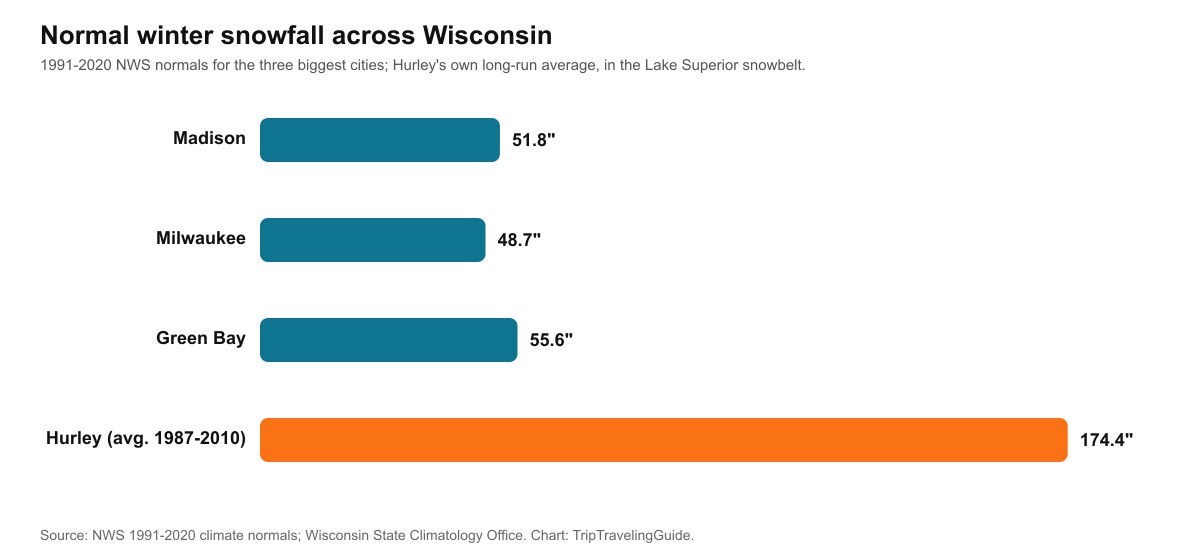
Yes, several times. The record holder is not one of the state's big cities. Hurley, in the far northern Lake Superior snowbelt, holds Wisconsin's seasonal snowfall record at 295.4 inches in the winter of 1996-97, and averaged 174.4 inches a season between 1987 and 2010, making it one of the snowiest towns in the country east of the Rockies.
Statewide, the snowiest winter on record is 2018-19, when the state's average snowfall topped 57 inches. Madison's own record season came in 2007-08, at 101.4 inches, almost double its 1991-2020 normal. Wisconsin's heaviest single-day snowfall on record is 26 inches at Neillsville, set on 27 December 1904.
How much snow does Wisconsin get in a normal year?
48 to 56 inches a season in the three biggest cities, with the far north running far higher thanks to the Lake Superior snowbelt. Madison's 1991-2020 normal is 51.8 inches, Milwaukee's is 48.7, and Green Bay's is 55.6, all from National Weather Service climate normals for each city's airport station.
| City or region | 1991-2020 seasonal normal | Record season |
|---|---|---|
| Milwaukee | 48.7 in | not in this guide's source set |
| Madison | 51.8 in | 101.4 in (2007-08) |
| Green Bay | 55.6 in | not in this guide's source set |
| Hurley (Lake Superior snowbelt) | 174.4 in (1987-2010 average) | 295.4 in (1996-97) |
How much snow falls each month in Wisconsin?
Almost all of it falls between December and February, and January is the single snowiest month. Milwaukee's 1991-2020 monthly normals, which add up exactly to its 48.7-inch seasonal total, show the season building from a light November and tapering off through March and April.
| Month | Milwaukee normal | Madison normal |
|---|---|---|
| October | 0.3 in | 0.6 in |
| November | 2.5 in | 3.0 in |
| December | 10.4 in | 12.0 in |
| January | 14.9 in | 13.7 in |
| February | 11.8 in | 12.8 in |
| March | 6.7 in | 7.0 in |
| April | 2.1 in | not in this guide's source set |
Madison's own monthly figures come from a separate NWS release and round slightly differently than its 51.8-inch seasonal normal, a small rounding gap rather than a contradiction. Either way, January and February together make up roughly half of an average Wisconsin winter's total snow.
Why does Hurley get so much more snow than the rest of Wisconsin?
Lake Superior's lake-effect snow. Hurley sits close enough to the lake's southern shore to catch heavy lake-effect snow, the same mechanism that buries towns on Lake Superior's Minnesota and Michigan shores: cold air crossing the open, relatively warm water picks up moisture and dumps it as snow on whatever land sits downwind. Madison, Milwaukee and Green Bay all sit further from the big lakes' heaviest lake-effect bands and rely mostly on ordinary storm systems instead.
Does Lake Michigan give eastern Wisconsin extra snow too?
Some, though less than Michigan's own shoreline gets from the same lake. Wisconsin sits on Lake Michigan's western shore, and the lake's lake-effect snowbands mostly form on the downwind, eastern side when the wind blows west to east, which usually pushes the heaviest totals toward Michigan rather than Wisconsin.
Advertisement
Southeastern Wisconsin's own lakeshore counties, Kenosha, Racine and Milwaukee, still catch real lake-effect bursts when the wind direction cooperates, and Door County, surrounded by both Lake Michigan and Green Bay, sees its own lake-effect events from either side of the peninsula. Our Michigan snow guide covers the same lake-effect mechanism from the side of the lake that gets it worst.
How much snow has Wisconsin gotten in the last 10 years?
Anywhere from a quiet 25.4 inches to a heavy 66.6, with no clean pattern of consistently rising or falling totals. Madison's calendar-year snowfall totals over the last decade, measured at Dane County Regional Airport, show just how much one winter can differ from the next even without a strong El Nino forcing it.
| Year | Madison snowfall |
|---|---|
| 2014 | 42.3 in |
| 2015 | 36.7 in |
| 2016 | 44.1 in |
| 2017 | 25.4 in |
| 2018 | 49.9 in |
| 2019 | 66.6 in |
| 2020 | 50.9 in |
| 2021 | 36.6 in |
| 2022 | 44.5 in |
| 2023 | 59.3 in |
These are calendar-year totals, January through December, not single winter seasons, so each number blends the tail end of one winter with the start of the next. Over these 10 years Madison averaged right around 45.6 inches, a bit under its 51.8-inch 30-year normal, which is itself built from a longer and somewhat snowier stretch of the record.
When does it usually start snowing in Wisconsin?
Mid-to-late November in the south, earlier in the north, per 30-year NOAA/NWS averages. Our first snow date guide covers the wider region in more detail, including how far the actual date can swing from that average in any single year.
What does this mean for winter travel in Wisconsin?
Plan around the state's real climate record rather than any one forecaster's headline. Our USA winter forecast hub compares NOAA and both almanacs across the whole country, and our Minnesota snow guide covers the same strong-El-Nino winter next door, where the three forecasters split in a similar way.
What are the limits of this forecast data?
A seasonal outlook describes a tendency across an entire winter, not a forecast for any single storm, flight or weekend, and this winter's three sources do not even agree with each other on the basic direction for snow. NOAA and the Old Farmer's Almanac lean below normal, the Farmers' Almanac leans above average, and Wisconsin's own record includes a severe storm, the 1991 Halloween Blizzard, that hit during an El Nino winter despite the seasonal odds.
We have not merged the three sources into one number, and nothing in this guide predicts a specific snowfall total for 2026-2027. For a seasonal outlook to matter for a specific trip, check the National Weather Service's short-range forecast for Wisconsin closer to your travel date rather than relying on any seasonal outlook alone.
Quick answers about Wisconsin's winter 2026-2027
Will Wisconsin have a snowy winter in 2026-2027?
Depends which forecaster you ask. NOAA and the Old Farmer's Almanac lean below normal, while the Farmers' Almanac calls Wisconsin above average for snow.
Will Wisconsin get a lot of snow this winter?
Possibly in short, sharp bursts even under a milder seasonal lean. All three sources describe real cold snaps and snowy windows within an otherwise warmer winter.
What kind of winter is predicted for Wisconsin?
A strong El Nino winter, warmer than normal overall, with disagreement among forecasters on whether total snowfall lands above or below normal.
What town gets the most snow in Wisconsin?
Hurley, in the far northern Lake Superior snowbelt, which holds the state's seasonal snowfall record at 295.4 inches, set in 1996-97.
What is Wisconsin's biggest snowstorm on record?
Wisconsin's heaviest single-day snowfall is 26 inches at Neillsville, set on 27 December 1904. For seasonal totals, Hurley's 295.4-inch 1996-97 season is the state record.
Did a major blizzard hit Wisconsin during a past El Nino winter?
Yes. The 1991 Halloween Blizzard dropped over 30 inches on parts of western Wisconsin during an El Nino winter, proof that a milder seasonal lean does not rule out a severe individual storm.
Sources
- NOAA Climate Prediction Center ENSO diagnostic discussion, 2026-2027 outlook
- Farmers' Almanac 2026-2027 winter forecast
- Old Farmer's Almanac 2026-2027 winter forecast
- National Weather Service 1991-2020 climate normals and monthly snow climatology, Milwaukee, Madison and Green Bay
- Current Results, Madison calendar-year snowfall totals, Dane County Regional Airport
- Wisconsin State Climatology Office, historical snowfall data
- National Weather Service, "1991 Halloween Blizzard/Ice Storm"
- Reporting on Hurley's seasonal snowfall record and Wisconsin's statewide snowiest winter, 2018-19
Topics
Advertisement